

Picterra provides sustainability leaders with a global GeoAI-powered intelligence hub for real-time environmental & supply chain insights. Our GeoAI platform transforms satellite and drone imagery into continuous, verifiable insights across land, supply chains, and ecosystems.
Trusted by organizations including British American Tobacco, DEFRA, Walter Matter, and The Nature Conservancy, Picterra facilitates a shift from fragmented, delayed data to real-time environmental visibility. Our cloud-native platform lets leaders detect what matters, act earlier, and build evidence-based strategies.
Headquartered in Switzerland, Picterra is redefining how environmental performance is monitored, verified, and scaled, making transparency and accountability a reality for global sustainability efforts.


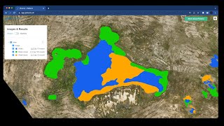
How Picterra verifies land eligibility for reforestation and agroforestry projects under VCS and CCB
Shared 4 months ago
71 views

Shared 7 months ago
52 views


Shared 1 year ago
506 views

Shared 1 year ago
226 views

Shared 1 year ago
337 views

Connect to a range of imagery servers in Picterra to build GeoAI models from 10cm satellite imagery!
Shared 1 year ago
117 views

Shared 1 year ago
155 views

Shared 1 year ago
359 views

Shared 1 year ago
632 views

Shared 1 year ago
1K views

Shared 1 year ago
228 views

Shared 1 year ago
347 views
Shared 1 year ago
104 views

Shared 1 year ago
104 views

Shared 1 year ago
4.8K views

Shared 1 year ago
334 views

Shared 1 year ago
582 views

Shared 1 year ago
256 views

Shared 1 year ago
158 views

Shared 1 year ago
200 views

Shared 1 year ago
150 views

Shared 1 year ago
124 views


Shared 1 year ago
5.7K views

Shared 1 year ago
691 views

Shared 1 year ago
853 views


Shared 2 years ago
333 views
Shared 2 years ago
821 views

Shared 2 years ago
1.1K views
Shared 3 years ago
1.1K views


Shared 4 years ago
2.2K views


Shared 4 years ago
346 views

Shared 5 years ago
3.1K views

Shared 5 years ago
895 views

Shared 5 years ago
2.7K views

Shared 6 years ago
9.9K views