Whether you're a student, researcher, professional, or curious learner, brings together the tools, knowledge, and real-world skills:
⭐ What We Learn
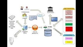
📐 Engineering & Land Surveying
Total Station tutorials
Levels & leveling practice
Traverse, topographic surveys, Cadastral
Field methods, workflows, and data processing
🛰️ Geomatics & Geoinformatics
GIS analysis & Remote sensing fundamentals
Cartography & map design
Coordinate systems & projections
🚁 Drone & UAV Mapping
UAV photogrammetry
LiDAR, multispectral, thermal workflows
Mission planning & flight
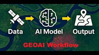
🧠 GeoAI
Deep Learning for geospatial
SAR analysis, environmental monitoring
🧭 Explore My Portfolio
See projects, research, maps, dashboards & UAV work:
👉 Portfolio: thapawan.github.io/Portfolio/
📘 Facebook
www.facebook.com/profile.php?id=100069796328000
📖 Blog
www.blogger.com/profile/00763349998740801159
📸 Instagram
www.instagram.com/learnsomethingstoday
🎵 TikTok
tiktok.com/@learnsomething46


Shared 1 month ago
24 views

Shared 1 month ago
41 views


Shared 4 months ago
19 views

Shared 4 months ago
37 views


Shared 1 year ago
88 views


Shared 2 years ago
393 views


Shared 4 years ago
144 views


Shared 5 years ago
1.7K views


Shared 5 years ago
66 views


Shared 5 years ago
151 views


Shared 5 years ago
527 views


Shared 5 years ago
103 views